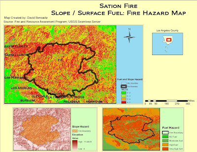
Dealing with raster spatial analysis, I learned very quickly that it has its own set of pitfalls that differ from vector data. With patience and focus I was able to apply the techniques from the tutorial to the analysis of the Station Fire in California. The process for me began with acquiring the data, which meant planning ahead. It was important to me to gather shapefiles from a common source in order to avoid any irregularities in their respective projections. In addition to downloading county, city boundary, and fuel shapefiles I had to acquire my own raster hill shade in order to create a slope. The most important methods that I had to implement were raster clipping of the hillshade, analysis masking and reclassification of the slope and fuel layers in order to create a presentable Hazard Map.
This lab illustrated the differences and the importance of being able to work with both vector and raster data on the same plane. You have to employ different modes of thinking when dealing with the two, and always make sure that your two forms of data are compatible with each other for the final combination of data. I had my own troubles with reclassifying the slope with spatial analysis as well as merging it with the fuel layer. The process of masking the layers to the county shapefile was also difficult for me. By working through these difficulties I was able to better understand the processes behind these techniques.
Although I had a few missteps along the way, I believe my map is quite clear in demonstrating the hazards within and around the Station Fire perimeter. I found that once I became more comfortable in dealing with raster data, the more possibilities I can see with working with it. Because raster data is likely a real world image, the results you gain from it are real world results. I realize that hazard maps are just a small portion of the potential of raster data. I will continue to use raster data in the future in order to paint a real world picture that many can relate to and understand.
No comments:
Post a Comment