Tuesday, February 22, 2011

Lab 6

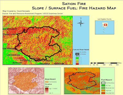
Dealing with raster spatial analysis, I learned very quickly that it has its own set of pitfalls that differ from vector data. With patience and focus I was able to apply the techniques from the tutorial to the analysis of the Station Fire in California. The process for me began with acquiring the data, which meant planning ahead. It was important to me to gather shapefiles from a common source in order to avoid any irregularities in their respective projections. In addition to downloading county, city boundary, and fuel shapefiles I had to acquire my own raster hill shade in order to create a slope. The most important methods that I had to implement were raster clipping of the hillshade, analysis masking and reclassification of the slope and fuel layers in order to create a presentable Hazard Map.

This lab illustrated the differences and the importance of being able to work with both vector and raster data on the same plane. You have to employ different modes of thinking when dealing with the two, and always make sure that your two forms of data are compatible with each other for the final combination of data. I had my own troubles with reclassifying the slope with spatial analysis as well as merging it with the fuel layer. The process of masking the layers to the county shapefile was also difficult for me. By working through these difficulties I was able to better understand the processes behind these techniques.

Although I had a few missteps along the way, I believe my map is quite clear in demonstrating the hazards within and around the Station Fire perimeter. I found that once I became more comfortable in dealing with raster data, the more possibilities I can see with working with it. Because raster data is likely a real world image, the results you gain from it are real world results. I realize that hazard maps are just a small portion of the potential of raster data. I will continue to use raster data in the future in order to paint a real world picture that many can relate to and understand.
Tuesday, February 15, 2011

Lab 5


There is a strong controversy coming from the small city of Kettleman in the San Joaquin Valley due to its proximity to a waste management and the possible health risks that come from it. These controversies related to the landfill project can be clarified through research, government transparency, and GIS techniques. With a focus on GIS we can gather information on issues ranging from pollution, recent birth defects, and safe work environments due to the proximity of the landfill to the city. The Waste Management Co. has made a proposal to the city legislature to make a major expansion and the denizens of the surrounding cities are not yet comfortable with this until the proper research and scientific testing is done from sources that they can trust in order to insure the future safety of the surrounding area. GIS can be a valuable tool in helping answer the questions in what is safe and fair to the surrounding cities while still gainful for the Waste Management Co.

The principal complaint from the people of the surrounding area is that they cannot trust the investigations that have taken place. Kettleman City residents feel there needs to be proper attention and investigation into the claims that that their proximity to the landfill has led to an unusual spike in birth defects in their city and surrounding area. The Kings County Department of Public Health claims "that the extent that a cluster [of birth defects] may exist, it is most likely a random event unrelated to any environmental exposure unique to Kettleman City." They citizens themselves don’t buy it; additional research from the State of California would help ease their minds.

Unfortunately, this has not been the case. The studies that have been conducted by the California Birth Defects Monitoring Program concluded that they could find no link between the site’s proximity to the city and the birth defects of the people. This study too has not been fully accepted by the citizens. The people believe that the methods used to test for such a link is flawed and do not trust the research over their anecdotal evidence of what they see in their neighborhoods. There is a fundamental breakdown in trust between the people of the city and the legislatures that are supposed to represent the people, therefore the people cannot comfortably put the health of them and their children into the government’s hands. With the clear data that GIS can potential provide the public will be more willing to accept the decisions of their local government.

GIS can help inform the public and local government about what is happening in proximity to the landfill based on a variety of factors. But GIS is based on the raw data you build from so the GIS research would have to be in conjunction with other credible research programs that would have no interest in the landfills expansion such as the EPA and California Department of Health and Safety. The techniques in this exercise can present a clear finding to the public that they can trust as well as be used by researchers to determine if expansion is safe or not.

This exercise is very useful in determining the suitably of the site. There are some problems that hinder the suitability analysis in expanding the landfill. The importance of one factor over another is not a finite measurement but rather a social construction that further fuels the debate. The subjective nature of the factors that go into determining the appropriation of the expansion can even further be hindered by the “NIMBY” stance of the residence which no amount of research, data, or GIS can overcome.


Wednesday, February 2, 2011

Quiz 1


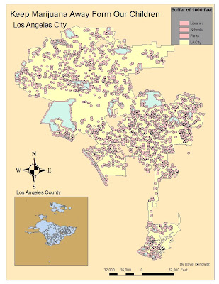
My map supports the government decision to put a 1000 foot buffer for marijuana dispensaries from schools, libraries and parks. I don't believe they should be legal at all let alone near our children to influence them. The exposure to such drugs could have significant long term effects on our youth in the future.

Some argue that marijuana dispensaries can bring in revenue to our city. Although our city is in a financial crisis, this is not the answer. But having a marijuana dispensary could also hurt other local businesses.

We must protect our youth so they can lead us in the future. There are still plenty of areas that these dispensaries could set-up, and they are probably more desirable locations for them anyways, such as Downtown Los Angeles. You can see these corridors as blank space on the map.