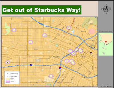
Geocoding is is the process of expressing point-coordinate features on a map by associating it with a street address or intersection. Geocoding is a very popular feature that is used by millions everyday in Google Maps and Places as well as Bing Maps to locate any address or landmark throughout the world. I thought I would take my project further by providing an analysis to the points I plotted.
 I started out by doing a simple Google Maps search to find every Starbucks Coffee in the Downtown Los Angeles. I used this information to create a my own address database. I repeated this process with "Non-Starbucks" coffee shops. I then geocoded the address database to the Streets layer of the StreetMap USA file and matched any nonconecting addresses. I then buffered the Starbucks with 500 ft and 750 ft.
My data solidifies the theory that Starbucks will not build a new store unless it is far enough away from competing coffee shops as well as have the ability to control a certain area's coffee needs. Downtown Los Angeles in one of the only truly compact areas in Los Angeles County, and you can see that "Non-Starbucks" coffee shops are compacted in a cluster while Starbucks is spread out with little outside competition. The 500 ft and 750 ft buffer represents a walking distance area of a Starbucks, and you can see that there is few competing coffee shops in walking distance from a Starbucks.
No comments:
Post a Comment