Firefighters were able to completely contain the blaze October 16. The fire burned a total of 160,000 acres, the 10th largest in California state history (CDFFP). Mostly fires in S. California are grassland fires,but the Station Fire was a true forest fire, as it burned primarily in the wooded hills of the Los Angeles National Forest (InciWeb). The flames threatened many homes in neighborhoods like La Canada, Flintridge, and Glendale (St. Fire info). 10,000 homes were evacuated as a precaution (CNN). In total, 64 structures were destroyed by the fire, and two firefighters were killed(St. Fire info).

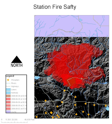
In the first map I aimed to show the spread of the fire from 45,000 acres to 160,000 acres in a few days. I displayed the lakes and rivers of the near-by area in hopes of displaying the possibilities of firefighters using this recourse to put-out the fire. I wanted to show how the rivers were unfortunately not able to contain the fires from spreading in that large over-growth area. Due to the fact that firefighters use helicopters to suck-up water to try and “rain-down” on the fire, I displayed the lakes in that area. A large water source is necessary to fuel these helicopters for easy and safe pick-up. I also displayed the large highways and hospitals in the area. This shows that there are not any roads that are contained within the fire, but if the fire were to go south, there are hospitals that could be used to treat near-by residents.

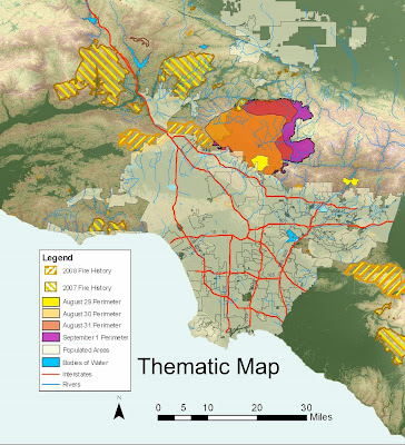
My aim with this map was to show areas of high risk of fire in Los Angeles. I showed the spread of the fire, with the vegetation of the area as well as the County of Los Angeles. The Station Fire broke out in an area where no fires had been for the past two years; there was no fire in the thickly-wooded Angeles National Forest for 62 years (CNN). The fire burned so quickly that it could not be contained. We can see that fires occur in rural areas and are contained before they reach the urbanized floor of the Los Angeles basin. Due to the tendency of fire to burn more efficiently uphill rather that downhill, the people of Los Angeles were very lucky to be below the burn. I also put past fire history to show that they have not recently reached to city, but also begs the question as to whether our policy should shift from containment to letting small fires happen naturally to prevent future large-scale burns.
I believe that my projections of the Station Fire shows the problems with our current fire-control policy in California. Due to the hard-blowing hot Santa Ana winds, the Los Angeles area is always going to be prone to fires. Although the cause of the fire is believed to be arson, better fire-protection is necessary. We need to control the amount of brush in the mountainous areas. This can be done naturally, by allowing fires to happen naturally so that there are often small-scale fires that will allow forest areas to relieve itself of the dead brush naturally; or the manually remove the brush with human intervention. I believe that policy that combines both methods will be the most effective.
Sites:
CAL FIRE
Inciweb
Station fire info
KTLA
No comments:
Post a Comment